Utility field workers and their office-bound supervisors have a lot of data to manage. In emergencies, they’ve got to report on downed power lines, broken-down equipment and other field assets to make sure they’re being repaired properly and safely. In the longer term, every asset deployed and work order performed has to be tracked, from the warehouse requisition form to the final documentation that is turned in to regulators and internal accounting departments.
Over the past few decades, these systems have evolved from old-fashioned and inefficient pen-and-paper systems to more modern software-and-mobile-device-driven applications purpose-built for the industry. But with the growing use of smart phones, tablets and the ubiquitous wireless networks that support them, utilities are starting to want systems that can talk to the wide world of mobile devices, as well as incorporate the data they’re delivering to an expanding set of applications.
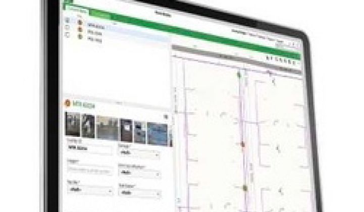
Enter Schneider Electric’s new Orbit solution, a software platform that integrates existing geographic information systems (GIS) and mobile workforce systems with both consumer-grade and utility-specific mobile devices. This isn’t a concept unique to Schneider, of course. Lots of mobile workforce connectivity systems are out there, ranging from smaller, long-time utility specialists like Clevest and Powel, to big grid contenders like ABB/Ventyx and new entrants like Cisco.
But Orbit differs from many other versions of this kind of GIS-mobile-utility enterprise integration, in that it uses the Microsoft Windows Azure cloud platform as its core, as Danny Petrecca, enterprise GIS product management director at Schneider, explained in an interview this week.
Using a cloud-based system should make data-sharing and integration much easier and more cost-effective than building interfaces between lots of legacy systems, he said. That, in turn, could open up the system to everything from utility operations modeling and planning software to the enterprise systems that drive decision-making at the executive level.
“The platform technology has finally caught up with the vision that people have about how to use geospatial technology in the field,” he said. “What people find useful in their daily lives, they bring to work. More and more people have smart phones and tablets -- and everything has a map in it."
Orbit, which officially launched on July 1, has been in testing with several unnamed utilities over the course of this year, Jason Brewington, director of product management for Schneider’s software-as-a-service (SaaS) and cloud computing solutions, said. The core functionality is built on the long-standing collaboration between GIS provider Esri and the asset and outage management systems of Schneider subsidiary Telvent.
One of Orbit’s first test cases has been what Brewington called “planned work,” or the regularly scheduled inspection and maintenance that all utilities perform on an ongoing basis. “One metric to look at is just the overall time that it takes an organization to go through the process of scheduling, assigning the work, having it completed, and seeing it arrive in systems,” he said.
Using Orbit has shown some significant benefits in cost, time, and accuracy, by streamlining those processes, he said. While Schneider and its test customers haven’t quantified those improvements yet, “With Orbit, we’re able to remove many, many links to that chain,” he said.
Schneider is also planning to integrate Orbit’s capabilities with utility operations like storm damage preparation and restoration, he said. “If you have the capability of putting a storm front on a map, you can proactively say, 'I need to get these materials ready, there are places on my overhead system that could be susceptible to high amounts of damage,'” he said, by way of example.
Once again, Schneider isn’t alone in tackling this kind of challenge. General Electric's Grid IQ Insight platform for outage detection, prevention and prediction suite, and ABB/Ventyx’s new outage lifecycle management system, represent similar efforts to integrate IT assets to manage utility outage restoration efforts -- including the input coming from mobile devices -- in a more holistic manner.
All of this effort is aimed at bringing the utility industry up to speed with what research firm Gartner calls the "consumerization" of geographical data, Petrecca said. While the utility GIS market is dominated by such players as Esri and Intergraph, or in-house products from grid giants like GE, Alstom and Siemens, we’ve also seen more utility vendors and startups seeking to take advantage of the rapidly growing amount of geographical data that’s built on standards-based platforms and open to broad-based development.
“What a lot of people are missing is that utilities have established GIS as an enterprise system that runs pretty much everything they do,” Petrecca said. That’s the same fact that’s driving the growth of startups like GIS integration specialist Space-Time Insight, along with collaborations like the partnership launched early this year between General Electric and Google Maps.
Smoothly integrating floods of field data from handheld mobile devices into this existing geographical context is an IT challenge, to be sure. No doubt we’ll be seeing many different approaches from competitors seeking to make their platforms a fully integrated part of what utilities do on a day-to-day basis.


 41
41
 15
15
 9
9