Before cities can upgrade and optimize their street lighting, they have to know where it's located and how it's performing. Scientists at MIT have developed a new sensor system to cheaply collect this data, which few governments currently have comprehensive access to.
Urban leaders are starting to unlock the benefits of "smart" lighting: replacing old bulbs with more efficient, networked LEDs that can be programmed to suit the needs of the location. These can save money and electricity by turning on when they detect people nearby, instead of running all night over empty streets. They can also modulate their brightness based on the time of day, instead of simply running at full strength or turning completely off.
To maximize this potential and ensure that streets have just the right amount of lighting where they need it, governments first have to have a detailed inventory of their lamps, including attributes like location, height, bulb type and brightness. That's proven surprisingly hard to achieve.
Despite the vital services of street lamps to encourage nightlife, deter crime and facilitate automotive safety, governments still largely rely on imperfect and pre-digital means to inspect and fix them when needed. At the moment, it would cost too much to put sensors on each lamp to signal when the bulb grows faint or dies, so cities use manual inspection, which is costly and time-consuming, or wait until citizens report an outage. That’s a precarious way to keep tabs on a massive infrastructural asset: in just the U.S., nearly 40 million street lights consume 31 terawatt-hours of electricity each year.
“If cities are trying to create a smarter, more sustainable environment, they need to collect data in a scalable, cost-effective way,” said Sumeet Kumar, who worked on this problem for his doctoral thesis at MIT. “You have to think about the cost of instrumentation.”
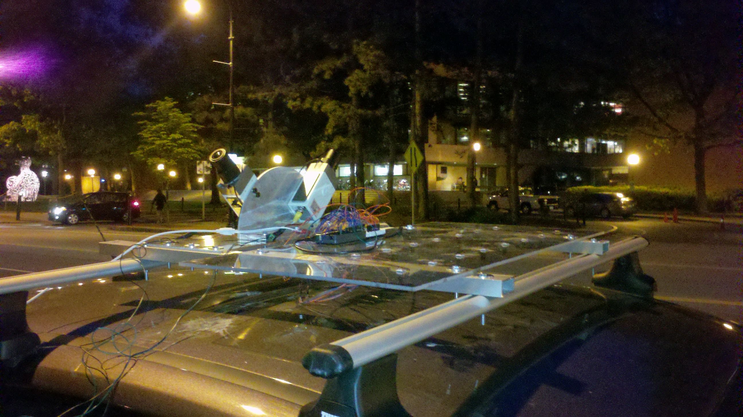
Kumar and his colleagues at MIT's Auto-ID Lab, a long-time leader in "internet of things" research, have developed a more effective and less costly approach. Inspired by Google’s Street View cars, they assembled a vehicle-mounted sensor array that records the location and brightness of lamps. An accompanying algorithm processes this data to create a regularly updated digital inventory of the lamps in a city, which the government can use to address poorly lit areas or plan for upgrades.
Source: MIT Auto-ID Lab
To further reduce the costs of data collection, the researchers suggest installing the sensors on government vehicles that regularly circumnavigate the community in the line of duty -- police cars, garbage trucks, buses and utility vans. This is what Auto-ID Lab Director Sanjay Sarma calls "incidental mapping" -- it leverages the work people are already doing to learn more about the environment they operate in.
"I’m a big believer in using information to fundamentally transform the way cities marshal their resources," Sarma said. "We’re building a city model of light."
The increasing availability of cheap, compact sensor technology aids this mission. Where accurate readings used to require bulky and expensive equipment, scientists can now take readings from a small contraption affixed to the roof of a car. Google popularized that method for photographically mapping the streets of the world, but, Kumar points out, the same approach could work for all aspects of city infrastructure. The MIT lab has already applied this methodology to inspecting street conditions (catching cracked pavement, debris, broken railings) and identifying heat leaking out of buildings due to inadequate insulation.
It can be hard to generate excitement for smart city advances like this, Kumar notes, because “they lack the sex appeal” of more individually oriented products. Anyone can grasp the value of an app like Uber or Lyft, because it gives the user a service right away; the ability to more cheaply and quickly identify malfunctioning street lamps really just applies to city governments and their contractors, because they're paying for that service in the first place. So far, Kumar says, they’ve heard more interest from European cities than American ones.
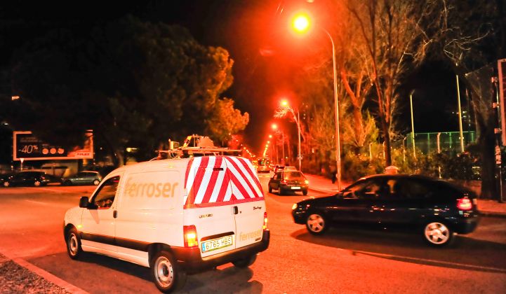
In fact, the research grew out of a request from European construction and municipal services company Ferrovial, which was seeking a better way to optimize the lighting they were responsible for. They sponsored the project and are seeking to operationalize it. The sensors and the algorithms have been figured out, but, Sarma noted, "practical inelegancies" creep in during real-world testing. He estimates it will take a year's effort to roll out the light-sensing apparatus in product form.
That gives other cities time to decide if they'd like a highly detailed map of their nocturnal illumination, or if they'd prefer to stay in the dark.
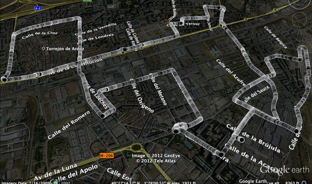
A luminosity map of the roads of Torrejon, Spain created by the data collected by the MIT light sensor system. (Courtesy of MIT Auto-ID Lab)


 41
41
 15
15
 9
9